
Introduction to Low Altitude Economy
Date:
I was kind of occupied by the term “low altitude economy” for a while recently. For example, I took the role of leader of the new MSc programme, the “low altitude economy (LAE)” and also joined several interview by Hong Kong TVB, RTHK and Mingbao from Hong Kong. It is quite clear that new business model can be established within the new LAE era and how can be grasp this opportunity is an interesting question!
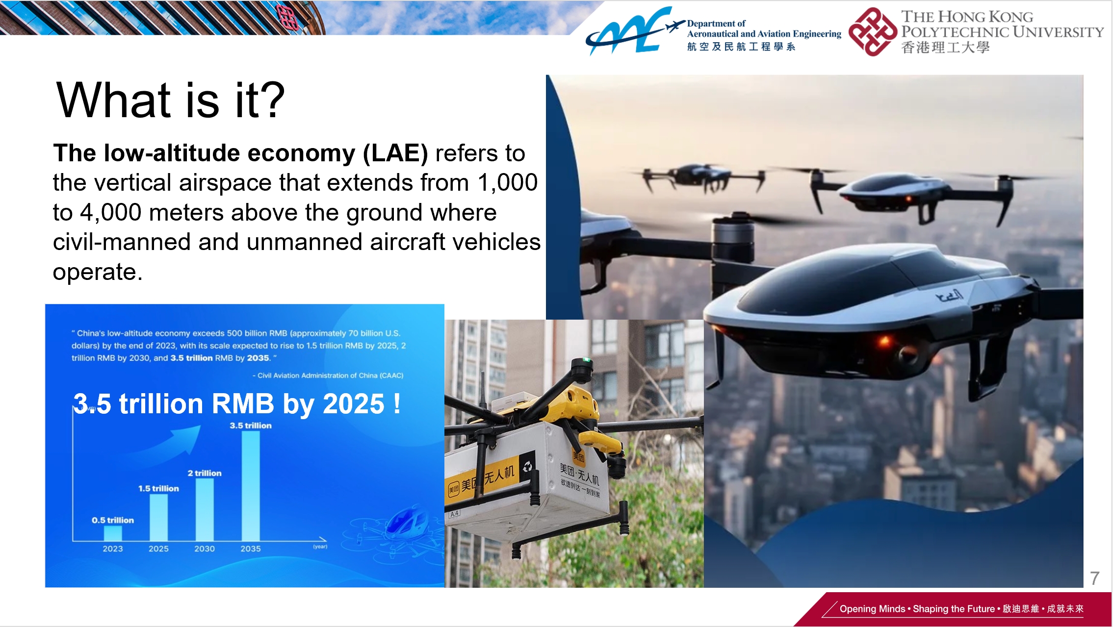
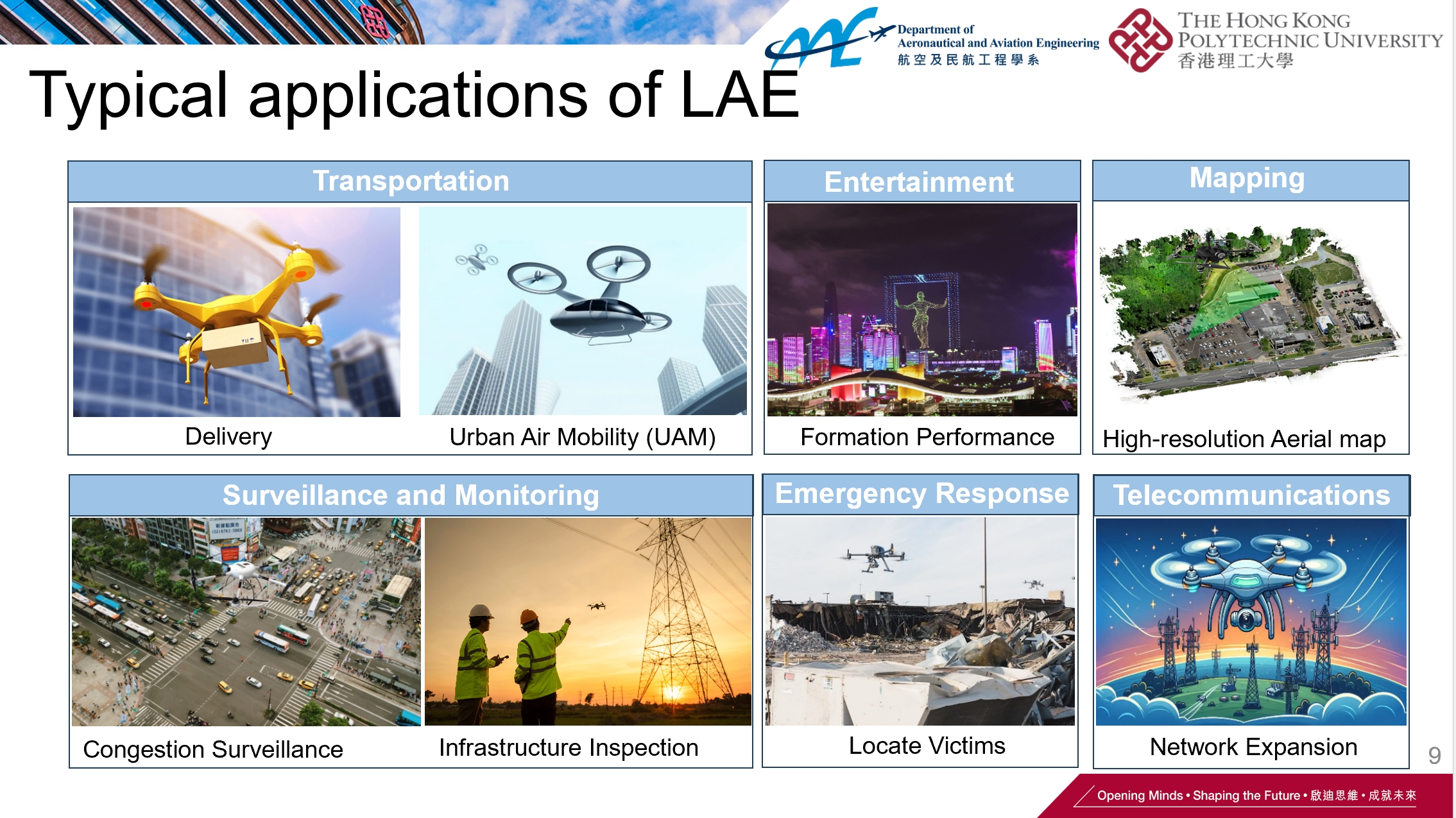
What is LAE?: The LAE refers to the economy activities within the 1000 meters, or possibly sometimely below the 3000 meters hight. The low altitude economy related to UAVs includes various industries and applications, such as:
- Agriculture: Drones are used for precision farming, including crop monitoring, spraying pesticides, and assessing plant health through aerial imagery.
- Delivery Services: Companies are exploring the use of drones for delivering goods, especially in hard-to-reach areas or for rapid delivery of time-sensitive items like medical supplies.
- Infrastructure Inspection: UAVs can inspect infrastructure like bridges, buildings, and power lines more safely and efficiently than human inspectors.
- Surveying and Mapping: Drones can quickly gather data for topographic maps, construction planning, and land surveys.
- Search and Rescue: In emergency situations, drones can be deployed to search for missing persons or to assess disaster-affected areas.
- Photography and Filmmaking: UAVs provide unique angles and perspectives for professional photography and film production.
- Environmental Monitoring: Drones can monitor wildlife, track environmental changes, and assess the health of ecosystems.
- Public Safety and Law Enforcement: UAVs can be used for crowd monitoring, crime scene analysis, and in other law enforcement activities.
Parcel delivery is close to our life?: From my research expertise, the most attractive sector to me is how the drones or unmanned aerial vehicles (UAV) can help to unclock the potential applications under the LAE. We may already see some news about using the UAV to do the percel delivery. However, the parcel delivery is hard to get into the massive production due to the several aspects: (1) the camera from the drone will lead to the privacy issue, where this be accepted by the customers? (2) the drones operation will affect the certain range of the airspace. Will this be acceptable to the government or the relevant authoritis? (3) Will the drone based parcel delivery really help to reduce the cost of parcel delivery if the orders are limited?
Window cleaning using drones: In this regard, I am always very interested in explore the new applications arising from the LAE. For example, we proposed to use the drones to enable the autonomous building cleaning. An video illustration is shown below.
Benefits of the window cleaning using the drones: Different from the existing solutions of window cleaning by workers climbing to the external wall of the buildings which is dangerous, the proposed solution included several benefits:
-
Safety: One of the most significant benefits is the reduction in risk to human life. Traditional window cleaning at great heights is dangerous, and accidents can be fatal. Drones can eliminate the need for cleaners to physically hang outside of buildings, thus reducing the risk of injury or death.
-
Efficiency: Drones can cover large areas quickly, potentially cleaning windows faster than manual methods. They can also be deployed rapidly and moved from one location to another with ease.
-
Cost-Effectiveness: Although the initial investment in drone technology might be significant, over time, the use of drones can reduce the costs associated with window cleaning. This is due to the decreased need for scaffolding, specialized equipment for high-rise access, and insurance costs related to the high-risk nature of traditional window cleaning.
-
Accessibility: Drones can reach areas that are difficult or impossible for human cleaners to access, such as complex architectural features, very tall buildings, or windows above sensitive ground areas where scaffolding cannot be erected.
-
Reduced Disruption: Traditional window cleaning methods can be disruptive to the daily operations of a building, requiring areas to be cordoned off for safety. Drones can minimize this disruption by quickly moving around the building and avoiding the need for extensive ground-level equipment setup.
-
Environmental Impact: Drones may use less water and fewer chemicals than traditional methods, as they can be equipped with precise spraying systems. This can lead to a more environmentally friendly cleaning process.
-
Data Collection: While cleaning, drones equipped with cameras can also inspect the building’s facade for maintenance issues, providing additional value beyond just cleaning.
-
Innovation and Adaptability: As drone technology continues to advance, new features and capabilities can be added to window-cleaning drones, such as improved cleaning systems, better battery life, and more precise navigation.
What is the scientific challenge in the front?: since we already see various kind of UAV applications, what are the main challenge in the front? From my point of view, almost 98% of the technology problems have been solved already. The rest problems are the long-tail challenges which may need lots of time to solve. Below is a figure to illustrate this phenomenon. Typically, the main components of the autonomous systems include the positioning, perception planning and control. For the typical application of the drone in urban canyons, the main challenges lie in the insufficient positioning and the control again strong external disturbances. However, it is hard to guarantee the safety of the system all the time. How can we quantify the safety or the risk of the system during the operation?
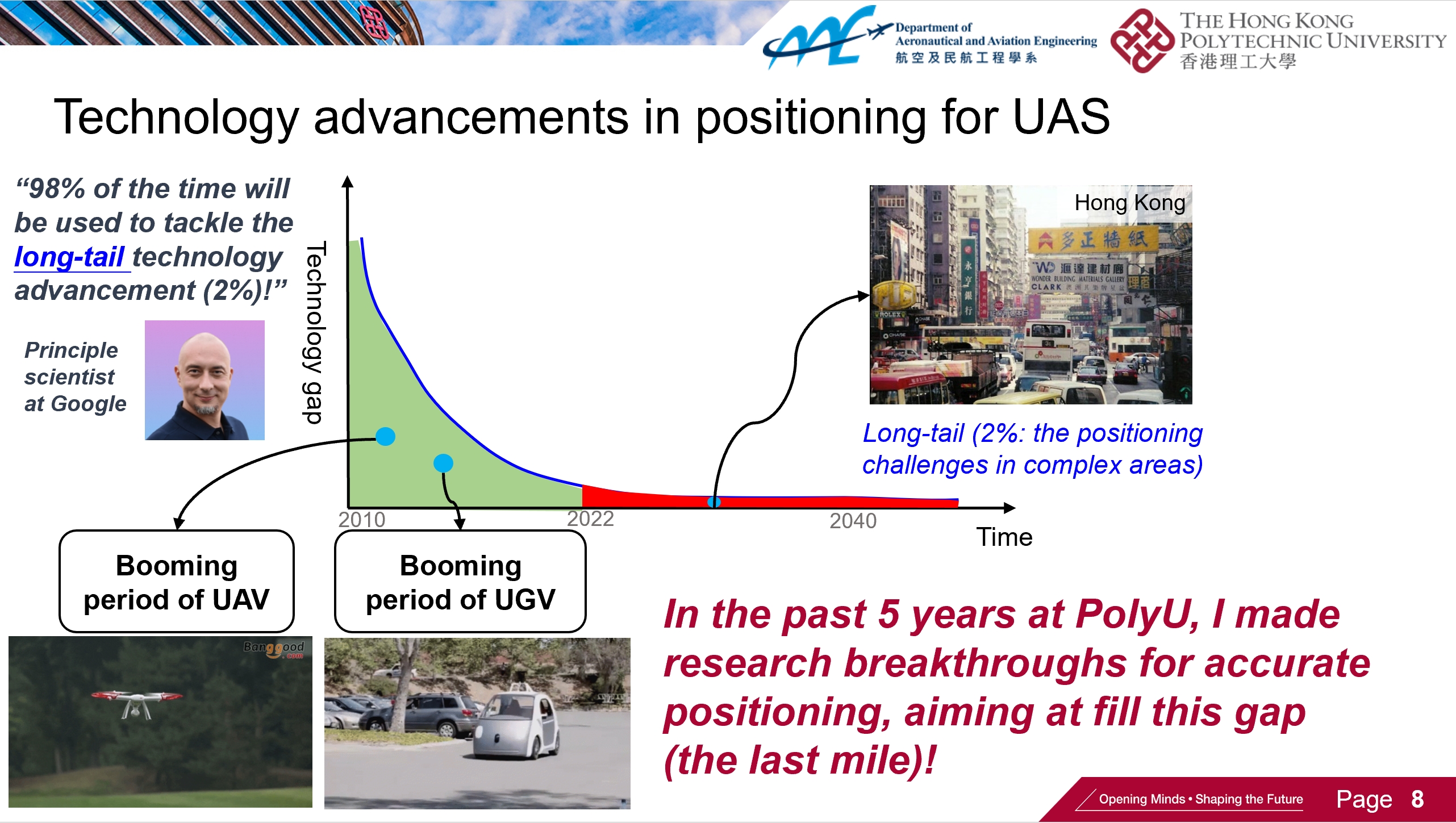
Safety quantification of the autonomous system may be the final solution to the long-tail phenomenon, instead of stick to the accuracy only!: Recently, the researchers from the MIT and Stanford reveals a new insight on the long-tail phenomenon of the autonomous system. They focus on quantify the risk of the perception or navigation system. Instead of insisting on improve the accuracy, they believe that we should know when the system will fail and then take proper action accordingly. For example, when we know that the positioning solution of the drone is unreliable, the drone can relief the parachute for safe landing. This is highly consistent with our research two research work [1-2] on both positioning and joint positioning/control.
[1] Yang, P., Wen, W., Bai, S., & Hsu, L. T. (2024). Tightly Joined Positioning and Control Model for Unmanned Aerial Vehicles Based on Factor Graph Optimization. arXiv preprint arXiv:2404.14724. [2] Xia, X., Hsu, L. T., & Wen, W. (2023, April). Integrity-constrained factor graph optimization for GNSS positioning. In 2023 IEEE/ION Position, Location and Navigation Symposium (PLANS) (pp. 414-420). IEEE.