
Safety-certifiable Multi-Sensor Fusion for Robotic Navigation in Urban Scenes
Dr. Li-ta Hsu, Dr. Wen, W., Dr. Jiachen Zhang, Zhengxi, Xiwei Bai, Feng Huang, Xikun Liu, Yihan Zhong.
Abstract
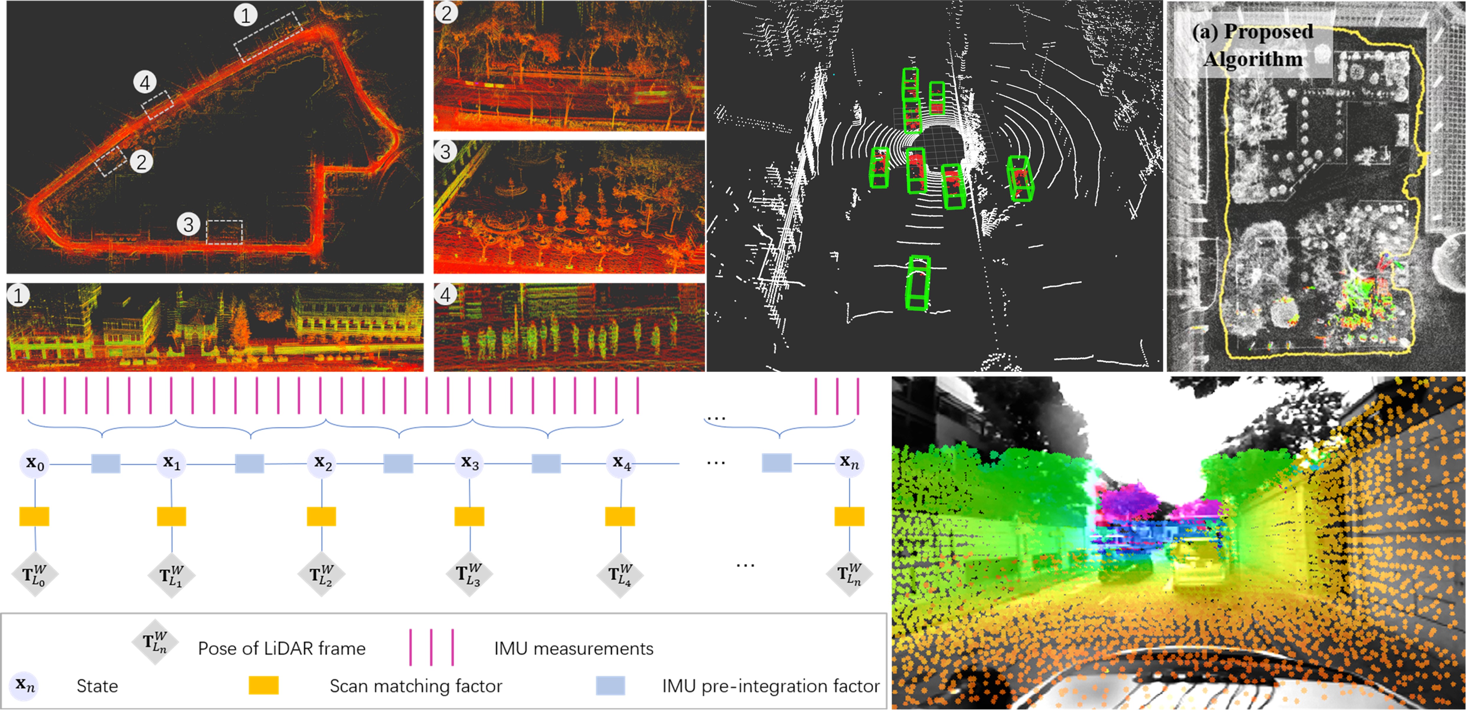
The visual/LiDAR SLAM methods are challenged in complex urban scenarios, especially when safety certification is required for autonomous systems. In this project, we aim to study the mechanism of the impacts caused by the dynamic scenarios on the visual/LiDAR SLAM methods, and develop safety-certifiable navigation algorithms that can quantify and guarantee the reliability of localization results. We try to answer the questions of how the dynamic objects affect the state estimation of visual/LiDAR SLAM methods, how to improve robustness, and how to provide safety-quantifiable localization for robotics in complex urban environments.
Recent News
-
The manuscript entitled “Safety-quantifiable Line Feature-based Monocular Visual Localization with 3D Prior Map” is submitted to the IEEE Transactions on Intelligent Transportation Systems. The video about this paper is available by Youtube and Bilibili. The preprint version can be found by Link.
- September 2022, 1 paper get accepted in IET Intelligent Transport Systems.
- Aug 2022, 1 paper on LiDAR SLAM get accepted in NAVIGATION: Journal of the Institute of Navigation
- Wen, W., & Hsu, L. T. (2022). AGPC-SLAM: Absolute Ground Plane Constrained 3D Lidar SLAM. NAVIGATION: Journal of the Institute of Navigation, 69(3).
Related Papers: (*: Corresponding author)
2025
- POPL-SLAM: A Pose-Only Representation-Based Visual-Inertial SLAM With Point and Structural Line Features. Li, T., Han, B., Yan, D., Wen, W., Wang, Z., Shi, C. IEEE Transactions on Aerospace and Electronic Systems, 62, 1509-1525, 2025. (IF: 5.7, JCR Q1)
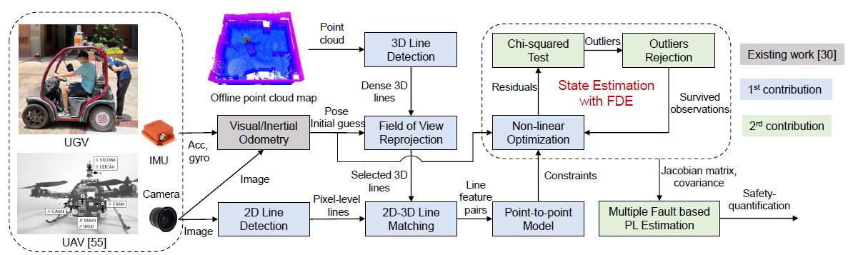
- Safety-quantifiable Line Feature-based Monocular Visual Localization with 3D Prior Map. Zheng, X., Wen, W.*, Hsu, L.T. IEEE Transactions on Intelligent Transportation Systems, 2025. (IF: 8.4, JCR Q1, Citations: 3)
- Fault Detection Algorithm for Gaussian Mixture Noises: An Application in Lidar/IMU Integrated Localization Systems. Yan, P., Li, Z., Huang, F., Wen, W., Hsu, L.T. NAVIGATION: Journal of the Institute of Navigation, 72(1), 2025. (IF: 3.1, JCR Q1, Citations: 6)
- Multi-Sensor Plug-and-Play Navigation Based on Resilient Information Filter. Meng, Q., Su, C., Jiang, Y., Wen, W., Meng, X. IEEE Sensors Journal, 2025. (IF: 4.5, JCR Q1)
- A Novel Lie Group-based Reliable IMM Estimation Method for SINS/GNSS/OD/NHC Integrated Navigation in Complex Environments. Du, S., Huang, Y., Wen, W., Zhang, Y. IEEE Internet of Things Journal, 2025. (IF: 8.9, JCR Q1, Citations: 5)
- Graph-Based Indoor 3D Pedestrian Location Tracking With Inertial-Only Perception. Bai, S., Wen, W.*, Su, D., Hsu, L.T. IEEE Transactions on Mobile Computing, 2025. (IF: 9.2, JCR Q1, Citations: 5)
2024
- Safety-Quantifiable Planar-Feature-based LiDAR Localization with a Prior Map for Intelligent Vehicles in Urban Scenarios. Zhang, J., Liu, X., Wen, W.*, Hsu, L.T. IEEE Transactions on Intelligent Vehicles, 2024. (IF: 14.3, JCR Q1, Citations: 2)
- Factor Graph Optimization-Based Smartphone IMU-Only Indoor SLAM With Multi-Hypothesis Turning Behavior Loop Closures. Bai, S., Wen, W.*, Hsu, L.T., Yang, P. IEEE Transactions on Aerospace and Electronic Systems, 2024. (IF: 5.7, JCR Q1, Citations: 9)
- Tightly-coupled Visual/Inertial/Map Integration with Observability Analysis for Reliable Localization of Intelligent Vehicles. Zheng, X., Wen, W.*, Hsu, L.T. IEEE Transactions on Intelligent Vehicles, 2024. (IF: 14.3, JCR Q1, Citations: 3)
- Integrity-Constrained Factor Graph Optimization for GNSS Positioning in Urban Canyons. Xia, X., Wen, W., Hsu, L.T.* NAVIGATION: Journal of the Institute of Navigation, 2024. (IF: 3.1, JCR Q1, Citations: 5)
- FGO-MFI: Factor Graph Optimization-based Multi-sensor Fusion and Integration for Reliable Localization. Zhu, J., Zhuo, G., Xia, X.*, Wen, W., Xiong, L., Leng, B., Liu, W. Measurement Science and Technology, 35(8), 086303, 2024. (IF: 3.4, JCR Q1, Citations: 7)
2023
- GLIO: Tightly-coupled GNSS/LiDAR/IMU Integration for Continuous and Drift-free State Estimation of Intelligent Vehicles in Urban Areas. Liu, X., Wen, W.*, Hsu, L.T. IEEE Transactions on Intelligent Vehicles, 2023. (IF: 14.3, JCR Q1, Citations: 52) (Code)
- Low-cost Solid-state LiDAR/Inertial Based Localization with Prior Map for Autonomous Systems in Urban Scenarios. Zhong, Y., Huang, F., Zhang, J., Wen, W.*, Hsu, L.T. IET Intelligent Transport Systems, 17(3), 474-486, 2023. (IF: 2.3, JCR Q2, Citations: 9)
2022
-
Zhong, Y., Huang, F., Zhang, J., Wen, W.*, Hsu, L.-T.: Low-cost solid-state LiDAR/inertial-based localization with prior map for autonomous systems in urban scenarios. IET Intell. Transp. Syst. 00, 1– 13 (2022). https://doi.org/10.1049/itr2.12273. (Paper, Video)
-
Wen, W., & Hsu, L. T. (2022). AGPC-SLAM: Absolute Ground Plane Constrained 3D Lidar SLAM. NAVIGATION: Journal of the Institute of Navigation, 69(3).(Paper)
-
Zhang, J., Wen, W*., Huang, F., Wang, Y., Chen, X., & Hsu, L. T. (2022). GNSS-RTK Adaptively Integrated with LiDAR/IMU Odometry for Continuously Global Positioning in Urban Canyons. Applied Sciences, 12(10), 5193. (Paper)
-
Feng Huang, Wen, W.*, Hoi-Fung Ng, Li-Ta Hsu, “LiDAR Aided Cycle Slip Detection for GNSS Real-time Kinematic Positioning in Urban Environments,” 2022 IEEE International Intelligent Transportation Systems Conference (ITSC), 2022 (accepted)
2021
-
Zhang, J.; Wen, W.*; Huang, F.; Chen, X.; Hsu, L.-T. Coarse-to-Fine Loosely-Coupled LiDAR-Inertial Odometry for Urban Positioning and Mapping. Remote Sens. 2021, 13, 2371. https://doi.org/10.3390/rs13122371 (Paper)
-
F. Huang, W. Wen, J. Zhang and L. -T. Hsu*, “Point Wise or Feature Wise? A Benchmark Comparison of Publicly Available Lidar Odometry Algorithms in Urban Canyons,” in IEEE Intelligent Transportation Systems Magazine, doi: 10.1109/MITS.2021.3092731.(Paper)
-
Huang, F., Shen, D., Wen, W., Zhang, J., Hsu, L., A coarse-to-fine LiDar-based SLAM with dynamic object removal in dense urban areas , ION GNSS+ 2021, St. Louis, Missouri, USA (Paper, Video)
-
Jiachen Zhang, Wen, W., Feng Huang and Li-Ta Hsu, Continuous GNSS-RTK Positioning Aided by LiDAR/Inertial Odometry with Intelligent GNSS Selection in Urban Canyons, ION GNSS+ 2021, St. Louis, Missouri, USA. (Paper, Video)
2020
-
X. Bai, B. Zhang, W. Wen, L. -T. Hsu and H. Li, “Perception-aided Visual-Inertial Integrated Positioning in Dynamic Urban Areas,” 2020 IEEE/ION Position, Location and Navigation Symposium (PLANS), 2020, pp. 1563-1571, doi: 10.1109/PLANS46316.2020.9109963.(Paper)
-
Bai, X., Wen, W. and Hsu, L.T., 2020. Robust visual-inertial integrated navigation system aided by online sensor model adaption for autonomous ground vehicles in urban areas. Remote Sensing, 12(10), p.1686. (Paper)
2019
- Wen, W., Bai, X., Zhan, W., Tomizuka, M. and Hsu, L.T., 2019. Uncertainty estimation of LiDAR matching aided by dynamic vehicle detection and high definition map. Electronics letters, 55(6), pp.348-349. (Paper)
2018
- Wen, W.; Hsu, L.-T.; Zhang, G. Performance Analysis of NDT-based Graph SLAM for Autonomous Vehicle in Diverse Typical Driving Scenarios of Hong Kong. Sensors 2018, 18, 3928. https://doi.org/10.3390/s18113928
Video Demonstration